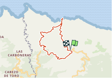
![](/images/other/stat-length.png)
![Randonnée Marche Santa Cruz de Ténérife - Canaries - Tenerife - Massif d'Anaga/Afur - jour 10 - Photo](https://media.geolcdn.com/t/1900/400/ext.pjpeg?maxdim=2&url=https%3A%2F%2Fstatic1.geolcdn.com%2Fsiteimages%2Fupload%2Ffiles%2F1553511878bg_sport_marche.png)
Canaries - Tenerife - Massif d'Anaga/Afur - jour 10
fhascoet
Utilisateur
![Longueur](/images/other/stat-length.png)
![Altitude max](https://static1.geolcdn.com/siteimages/upload/files/1508320355ic_sort_altitude_max_24dp.png)
![Dénivelé positif](https://static1.geolcdn.com/siteimages/upload/files/1508320355ic_sort_den_pos_24dp.png)
![Km-Effort](/images/other/stat-length.png)
![Altitude min](https://static1.geolcdn.com/siteimages/upload/files/1508320355ic_sort_altitude_min_24dp.png)
![Dénivelé négatif](https://static1.geolcdn.com/siteimages/upload/files/1508320355ic_sort_den_neg_24dp.png)
![Boucle](https://static1.geolcdn.com/siteimages/upload/files/16400158638029165_repeat_loop_refresh_sync_direction_icon.png)
![Marche](https://static1.geolcdn.com/sitytour/trail-icons/101.png)
6h54
Difficulté : Très difficile
![Scannez ce code QR pour ouvrir la randonnée dans l'application SityTrail](https://capi.geolives.com/qq0zvz2zws4bq2lad0pu/sitytour/trails/2921085/qr.png?size=200)
Application GPS de randonnée GRATUITE
À propos
Randonnée Marche de 10,2 km à découvrir à Îles Canaries, Santa Cruz de Ténérife, Santa Cruz de Ténérife. Cette randonnée est proposée par fhascoet.
Description
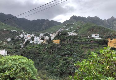
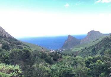
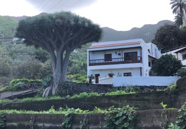
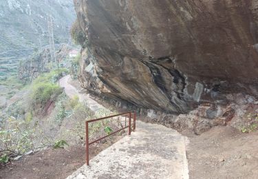
Départ du petit village d'Afur au bout d'une très belle route serpentant dans la montagne.
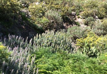
Très belle descente dans le barranco jusqu’à la mer ( baignade très difficile à cause des cailloux et des rouleaux)
Remontée par un ancien chemin, peu entretenu, jusqu'au village de Taborno. Cette montée est très belle mais difficile avec quelque passages dans les broussailles.
Retour à Afur partiellement par la route.
Durée avec les arrêts (déjeuner à la plage ...)
Localisation
Commentaires
Randonnées à proximité
![Randonnée Marche San Cristóbal de La Laguna - Massif de l'Anaga El Batan Chinamada - Photo](https://media.geolcdn.com/t/375/260/bf287400-cf63-4351-bbc9-dbe9aba0fa64.jpg&format=jpg&maxdim=2)
![Marche Marche](https://static1.geolcdn.com/sitytour/trail-icons/101.png)
Marche
![](/images/other/stat-length.png)
![](https://static1.geolcdn.com/siteimages/upload/files/16400158638029165_repeat_loop_refresh_sync_direction_icon.png)
![Randonnée A pied Tegueste - El bosque de los enigmas - Photo](https://media.geolcdn.com/t/375/260/1a03fed7-fb28-4a0e-9d0f-13adda6bed3b.jpeg&format=jpg&maxdim=2)
![A pied A pied](https://static1.geolcdn.com/sitytour/trail-icons/100.png)
A pied
![](/images/other/stat-length.png)
![](https://static1.geolcdn.com/siteimages/upload/files/16400158638029165_repeat_loop_refresh_sync_direction_icon.png)
![Randonnée Marche Santa Cruz de Ténérife - 20230128 boucle Tâcheron - Amalciga - Photo](https://media.geolcdn.com/t/375/260/b1f1dc85-b9e4-4caa-b65a-f459c97ad4be.jpg&format=jpg&maxdim=2)
![Marche Marche](https://static1.geolcdn.com/sitytour/trail-icons/101.png)
Marche
![](/images/other/stat-length.png)
![](https://static1.geolcdn.com/siteimages/upload/files/16400158638029165_repeat_loop_refresh_sync_direction_icon.png)
![Randonnée Marche Santa Cruz de Ténérife - 20230125 Tachero-Taganana-Casa Forestal - Photo](https://media.geolcdn.com/t/375/260/71cc47a6-b1dd-4c81-86b4-433999439594.jpg&format=jpg&maxdim=2)
![Marche Marche](https://static1.geolcdn.com/sitytour/trail-icons/101.png)
Marche
![](/images/other/stat-length.png)
![](https://static1.geolcdn.com/siteimages/upload/files/16400158638029165_repeat_loop_refresh_sync_direction_icon.png)
![Randonnée Marche Santa Cruz de Ténérife - 20230123 Tachero-Taganana-Afur-Tamarides-Taganana - Photo](https://media.geolcdn.com/t/375/260/5e74cb13-69fc-4368-a6b5-97a9ce371819.jpg&format=jpg&maxdim=2)
![Marche Marche](https://static1.geolcdn.com/sitytour/trail-icons/101.png)
Marche
![](/images/other/stat-length.png)
![](https://static1.geolcdn.com/siteimages/upload/files/16400158638029165_repeat_loop_refresh_sync_direction_icon.png)
![Randonnée Marche Santa Cruz de Ténérife - 20230121 Tacheros-Taganana- el Baleiros - Photo](https://media.geolcdn.com/t/375/260/d3298b11-553a-417f-a8c1-0c2a9e5ffc75.jpg&format=jpg&maxdim=2)
![Marche Marche](https://static1.geolcdn.com/sitytour/trail-icons/101.png)
Marche
![](/images/other/stat-length.png)
![](https://static1.geolcdn.com/siteimages/upload/files/16400158638029165_repeat_loop_refresh_sync_direction_icon.png)
![Randonnée Marche San Cristóbal de La Laguna - Las Carbonaras Chimada AR - Photo](https://media.geolcdn.com/t/375/260/b1c626c3-3510-4ce3-890e-282b82838da6.jpg&format=jpg&maxdim=2)
![Marche Marche](https://static1.geolcdn.com/sitytour/trail-icons/101.png)
Marche
![](/images/other/stat-length.png)
![](https://static1.geolcdn.com/siteimages/upload/files/16400158638029165_repeat_loop_refresh_sync_direction_icon.png)
![Randonnée Marche Santa Cruz de Ténérife - Afur - Taganana - Photo](https://media.geolcdn.com/t/375/260/3c968652-f4ba-48a3-a0da-108b9b20f163.jpg&format=jpg&maxdim=2)
![Marche Marche](https://static1.geolcdn.com/sitytour/trail-icons/101.png)
Marche
![](/images/other/stat-length.png)
![](https://static1.geolcdn.com/siteimages/upload/files/16400158638029165_repeat_loop_refresh_sync_direction_icon.png)
![A pied A pied](https://static1.geolcdn.com/sitytour/trail-icons/100.png)
A pied
![](/images/other/stat-length.png)
![](https://static1.geolcdn.com/siteimages/upload/files/16400158638029165_repeat_loop_refresh_sync_direction_icon.png)